About the Project
Mangrove ecosystems of the greater Caribbean region face growing threats from increasingly frequent tropical cyclones. The resilience of these ecosystems is being tested by the combined effects of cyclones, sea level rise, hydrologic changes, and coastal development. In 2017, Jobos Bay NERR and Rookery Bay NERR sustained severe impacts from Hurricanes Maria and Irma, respectively. Just five years later, both reserves were again impacted by powerful hurricanes (Hurricanes Fiona and Ian). Both reserves realized a need to understand storm impacts and recovery trends in mangrove forests. A team of scientists, managers, and educators from Florida and Puerto Rico came together to address this need through the Mangrove Coast Collaborative project and the Limits to Resilience project. These projects have strengthened partnerships between the two reserves, increased understanding of the factors influencing recovery from hurricanes in Puerto Rico and Florida, and informed management to better maintain resilient mangrove forests.
About the Resource
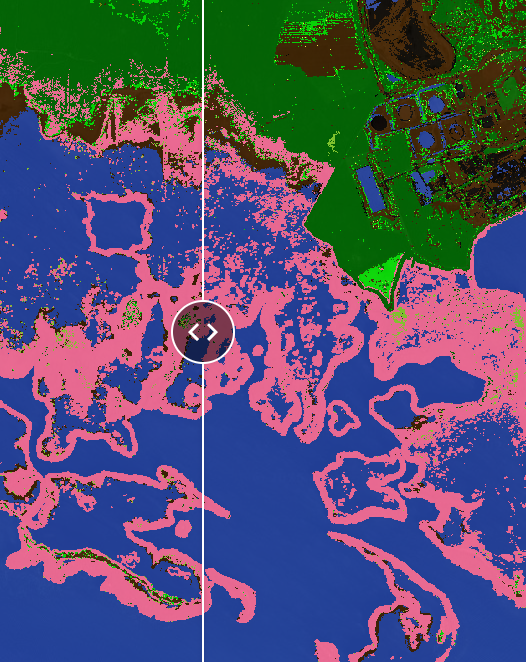
While mangrove systems are adapted to storm impacts and thus have the ability to recover from storm damage or effects, some mangrove ecosystems don’t always recover as well as they are expected to. Lack of recovery in these systems post-storm can be linked to many possible factors, including climatic influences or anthropogenic drivers. To better visualize areas impacted by recent hurricanes with low mangrove recovery, this project team created time series maps for Rookery Bay NERR and Jobos Bay NERR, with an emphasis on mangrove coverage.
These interactive annual maps show terrestrial habitat cover for years between 2014 and 2024 for Rookery Bay and Jobos Bay. During these years, the reserves sustained impacts from multiple hurricanes (Jobos Bay NERR: Hurricane Maria, 2017; Hurricane Fiona, 2022; Rookery Bay NERR Hurricane Irma, 2017; Hurricane Ian, 2022)
The maps were produced using multispectral imagery from WorldView satellites (acquired through the NASA Commercial Satellite Data Access program), digital elevation models from the USGS, and ground truth data collected for this project. The application allows for direct visual comparison between years, and the associated source code supports development of future projects utilizing this dataset.
The published dataset is 2-m resolution with classes including 'shadow,' 'clouds,' 'natural non-vegetated,' 'water,' 'dead grass,' 'marsh,' 'scrub,' 'mixed low-relief vegetation,' 'mixed upland vegetation,' 'mangrove,' and 'high-reflectance non-vegetated.'
Habitat Cover Maps
Google Earth Engine Source Code and Datasets
To access the Google Earth Engine source code and datasets for these maps, you must have a Google account as well as a Google Earth Engine account. Google Earth Engine is free for academic and noncommercial use.