Coastal communities around the country face rising seas and tidal flooding and must find creative solutions to protect low-lying roads, homes, and other coastal infrastructure.
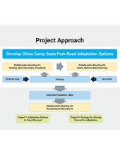
A catalyst project, A Collaborative Process to Develop Solutions for Tidal Road Flooding in China Camp State Park, offers a potential model for other communities facing similar threats to coastal infrastructure. The project blended technical expertise and active community participation to initiate adaptation planning from the bottom up. A facilitated process brought together a wide range of stakeholders representing diverse local interests to identify and evaluate adaptation options for the road. New field research improved understanding of the extent to which sea level rise influences the shoreline, marsh, and North San Pedro Road. Project workshops helped generate a clearly defined set of adaptation options and their pros and cons, and created a strategy to move forward with planning and implementation.
About this Resource
Project meeting slides, public documents, and a suite of related references are archived here to assist others interested in learning from and adapting their approach.
A series of project reports describe the stakeholder process and project outcomes in greater detail: China Camp Road Adaptation: Options and Qualitative Evaluation Report; Road Map to Implementation; and Existing Conditions Report (available soon).
Documents from Project Stakeholder Meetings
Meeting 1 Slides (Fall 2018) - The road problem in a nutshell
Reference - Draft goals and feasibility criteria for project
Meeting 2 Slides (Winter 2019) - Water levels and road flooding
Reference - Goals, implementation feasibility considerations, and design considerations
Reference - Planning horizons, road corridor goal, and first draft of road adaptation options
Meeting 3 Slides (Summer 2019) - Evaluation of options
Additional Resources and References
Regional scale assessments and strategies:
Marin Bay Waterfront Adaptation Vulnerability Assessment, County of Marin
San Francisco Bay Shoreline Adaptation Atlas, San Francisco Estuary Institute and the Aquatic Science Center
Sea Level Rise Adaptation Framework, Blue Point Conservation Science
Projects that exemplify technical, collaborative and engagement approaches with applicability to China Camp:
Sonoma Creek Enhance Project, Audubon California
Aramburu Island Enhancement Project, Richardson Bay Audubon
Sears Point Wetland Restoration, Sonoma Land Trust
Suisun Marsh Conservation Assessment, Report for the Nature Conservancy, 2011
South Bay Salt Pond Restoration Feasibility Analysis, Wetlands and Water Resources Report, 2002
Suisan Marsh Today: Agents of Change, Chapter in 2014 Book by Peter Moyle
Using Conceptual Models and Decision-Support Tools to Guide Ecosystem Restoration Planning and Adaptive Management: An Example from the Sacramento-San Joaquin Delta, California, Article in San Francisco Estuary & Watershed Science, 2012
Questions about these resources can be directed to:
Stuart Siegel, Coastal Resilience Specialist, San Francisco Bay NERR, siegel@sfsu.edu
Aimee Good, Coastal Training Program Coordinator, San Francisco Bay NERR, aimee@sfsu.edu