Since Hurricane Sandy battered the New Jersey coastline in 2012, coastal decision makers have been inundated with data, tools, assessment techniques, and planning guidance to help them prepare communities to face future extreme storm events. The Jacques Cousteau National Estuarine Research Reserve and Rutgers University climate resilience experts worked to streamline and enhance existing mapping and decision-support tools. The result was New Jersey Flood Mapper, an interactive, user-centered web tool that enables decision-makers to visualize exposure from coastal flooding hazards. Updates to the tool have also enabled visualization of projected future change in salt marshes due to sea level rise.
Visualizing flood risk
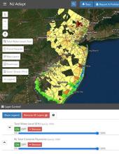
New Jersey Flood Mapper helps coastal decision-makers visualize flood risk due to sea level rise and extreme storms. The tool operationalized a total water level concept developed by Rutgers climate resilience experts to allow planners to evaluate a range of flood conditions and time horizons. Enhanced map overlays and data layers that show physical infrastructure, evacuation routes, and socio-demographic information are integrated into the tool to give a fuller picture of community vulnerability.
Informing salt marsh and mosquito management
The tool can also be used to inform salt marsh management under a changing climate and sea level rise, including informing nuisance mosquito management. The New Jersey Flood Mapper incorporates maps produced using the Sea Level Affecting Marshes Model (SLAMM) to visualize projected future change in the marsh-forest interface zone. The future modeling and marsh-upland edge mapping suggests that the marsh-upland transition zone is and will be a hotspot for change. Field sampling confirms that these “new ” habitats can serve as breeding areas for target mosquito species and thereby represent an area of concern for mosquito control agencies.